Unlocking the Skies: Sectional Charts
Day 2 - All About Sectional Charts#
If someone told me a year ago that I’d be poring over sectional charts and learning about airspace classes in preparation for the Part 107 Drone Certification, I might have laughed it off. Yet, here I am, navigating the skies (at least, in my studies) and gearing up to join the ranks of certified drone pilots.
Sectional Charts: The Road Maps of the Sky#
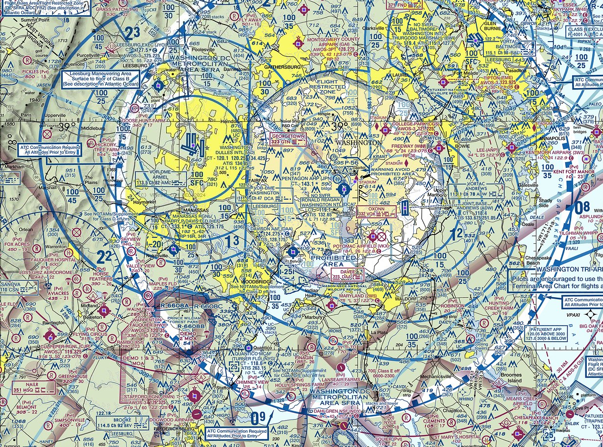
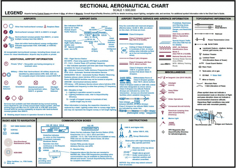
 As a drone pilot, understanding sectional charts is crucial. These charts are like road maps for the sky, providing information for flights below 18,000 feet. With over 50 charts covering the U.S., updated every six months, they’re essential for navigating our airspace. They’re packed with valuable data that I’ve learned to decode, such as:
-
Visual Flight Rules (VFR): These are aviation regulations allowing operations based on visual references outside the cockpit, rather than instruments.
-
Latitude and Longitude: Latitude runs east to west (like the equator at 0º latitude) and longitude runs north to south (like the prime meridian at 0º longitude).
-
AGL and MSL: Above Ground Level (AGL) is absolute altitude, while Mean Sea Level (MSL) is true altitude.
-
VFR Checkpoints: Visual points of reference marked by magenta flags.
-
Notification Boxes: Blue rectangles providing text info about areas and features.
-
Isogonic Lines: Show the magnetic variation between true north and magnetic north, represented by magenta dashed lines.
-
Maximum Elevation Figures: Indicate the highest elevation in a given quadrangle with blue or magenta numbers.
-
Airport Icons & Data: Include details like airport name, runway length, and communication frequencies, marked with blue or magenta text above the icon.
-
Obstructions: Man-made structures, with upside-down Ys indicating 1000+ feet AGL, and ^ symbols for under 1000 feet AGL.
You can visit https://vfrmap.com to gain some experience understanding sectional charts

Deciphering Airspace Classes#

Understanding the different classes of airspace is another key component of drone certification:
-
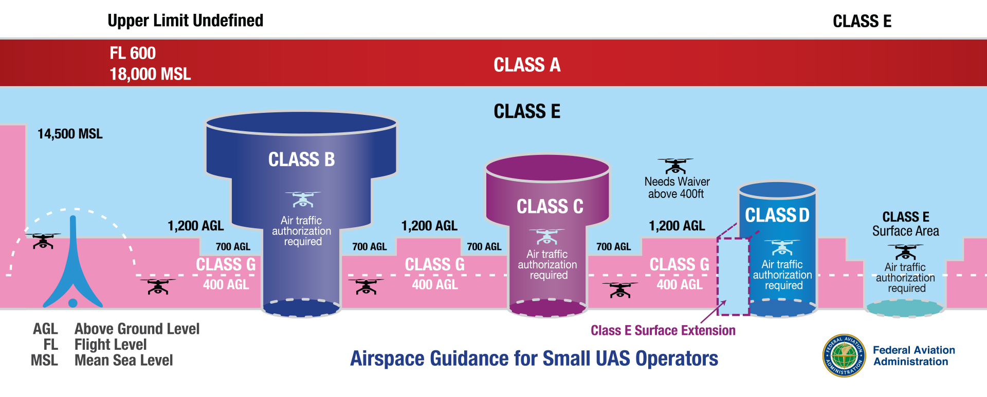
Class B: This airspace surrounds the busiest airports in the U.S. (“B” for Big City Airport). It has vertical limits from the surface to 10,000 feet MSL and lateral limits extending up to 30 nautical miles. Solid blue lines on sectional charts indicate Class B airspace.
-
Class C: Found around smaller city airports (“C” for cities), with vertical limits up to around 4,000 feet MSL and lateral limits extending up to 10 nautical miles. Solid magenta lines on sectional charts represent Class C airspace.
-
Class D: Small towered airports (“D” for dime-sized) fall under this class, with vertical limits up to around 2,000 feet MSL and lateral limits extending up to 4-5 nautical miles. Dashed blue lines on sectional charts signify Class D airspace.
-
Class E: This is airspace outside of other classes (“E” for everywhere), with vertical limits that can start at the surface, 700 feet, or 1,200 feet AGL, extending up to 18,000 feet MSL. It does not require FAA-approved airspace authorization unless in an airport surface area. It’s depicted with dashed magenta lines for surface and magenta or blue vignette (fuzzy lines) for 700 and 1,200 feet respectively.
-
Class G: This is uncontrolled airspace not designated as anything else, where most Part 107 operations occur. It extends from the surface to the Class E transition and is not shown on sectional maps.
Special Use Airspace and Other Considerations#
There are also special use airspaces, such as Prohibited, Restricted, Warning, Military Operations Areas (MOAs), and Alert areas. While drones may fly in some of these areas, remote pilots in command (RPICs) must exercise extreme caution and may need to coordinate for permission.
Additionally, being aware of Notices to Air Missions (NOTAMs) and Temporary Flight Restrictions (TFRs) is critical. NOTAMs provide notifications for abnormal statuses that are important for all pilots to conduct proper pre-flight checks. TFRs, a type of NOTAM, are specific to airspace changes, such as those for presidential movements, major events like the Super Bowl, or emergency situations like wildfires.
Wrapping Up#
Studying for the Part 107 Drone Certification has been an eye-opening journey. From learning to read sectional charts to understanding airspace classes and special use areas, every step brings me closer to safely and effectively operating my drone. It’s a fascinating world up there, and I’m excited to soon be a certified part of it.
Quiz time#
FAA resources and practice exams can be found here. All figures referenced in the below questions can be found here. (Refer to FAA-CT-8080-2H, Figure 22, area 2.) At Coeur D`Alene which frequency should be used as a Common Traffic Advisory Frequency (CTAF) to monitor airport traffic? A. 122.05 MHz. B. 135.075 MHz. C. 122.8 MHz. C (Refer to FAA-CT-8080-2H, Figure 23, area 3.) What is the floor of the Savannah Class C airspace at the shelf area (outer circle)? A. 1,300 feet AGL. B. 1,300 feet MSL. C. 1,700 feet MSL. B (Refer to FAA-CT-8080-2H, Figure 20, area 3.) With ATC authorization, you are operating your small unmanned aircraft approximately 4 SM southeast of Elizabeth City Regional Airport (ECG). What hazard is indicated to be in that area? A. High density military operations in the vicinity. B. Unmarked balloon on a cable up to 3,008 feet AGL. C. Unmarked balloon on a cable up to 3,008 feet MSL. C (Refer to FAA-CT-8080-2H, Figure 21.) You have been hired by a farmer to use your small UA to inspect his crops. The area that you are to survey is in the Devil’s Lake West MOA, east of area 2. How would you find out if the MOA is active? A. Refer to the chart legend. B. This information is available in the Small UAS database. C. Refer to the Military Operations Directory. A The most comprehensive information on a given airport is provided by A. the Chart Supplements U.S. (formerly Airport Facility Directory). B. Notices to Airmen (NOTAMS). C. Terminal Area Chart (TAC). A (Refer to FAA-CT-8080-2H, Figure 26, area 4.) You have been hired to inspect the tower under construction at 46.9N and 98.6W, near Jamestown Regional (JMS). What must you receive prior to flying your unmanned aircraft in this area? A. Authorization from the military. B. Authorization from ATC. C. Authorization from the National Park Service. B (Refer to FAA-CT-8080-2H, Figure 20, area 5.) How would a remote PIC “CHECK NOTAMS” as noted in the CAUTION box regarding the unmarked balloon? A. By utilizing the B4UFLY mobile application. B. By contacting the FAA district office. C. By obtaining a briefing via an online source such as: 1800WXBrief.com. (or NOTAMS.AIM.FAA.GOV) C (Refer to FAA-CT-8080-2H, Figure 21.) What airport is located approximately 47 (degrees) 40 (minutes) N latitude and 101 (degrees) 26 (minutes) W longitude? A. Mercer County Regional Airport. B. Semshenko Airport. C. Garrison Airport. C (Refer to FAA-CT-8080-2H, Figure 59, area 2.) The chart shows a gray line with “VR1667, VR1617, VR1638, and VR1668.” Could this area present a hazard to the operations of a small UA? A. No, all operations will be above 400 feet. B. Yes, this is a Military Training Route from the surface to 1,500 feet AGL. C. Yes, the defined route provides traffic separation to manned aircraft. B (Refer to FAA-CT-8080-2H, Figure 26.) What does the line of latitude at area 4 measure? A. The degrees of latitude east and west of the Prime Meridian. B. The degrees of latitude north and south of the equator. C. The degrees of latitude east and west of the line that passes through Greenwich, England. A Your surveying company is a title sponsor for a race team at the Indianapolis 500. To promote your new aerial surveying department, you decide to video part of the race using a small UA. The FAA has issued a Temporary Flight Restriction (TFR) for the race in the area you plan to fly. In this situation A. you may fly your drone in the TFR since your company is sponsoring a team at the race. B. the TFR applies to all aircraft; you may not fly in the area without a Certificate of Waiver or Authorization. C. flying your drone is allowed if you notify all non-participating people of the closed course UA operation. B